Slightly overshadowed by the more famous Watling Street and Fosse Way, Ackling Dyke is Dorset’s most prominent Roman Road. Running for around 22 miles (35 km) from Old Sarum (Sorviodunum) to Badbury Rings, this spectacular Roman road survives in places as a substantial raised agger, still clearly visible in the landscape. But Ackling Dyke was never an isolated road. At Old Sarum it connected with routes leading north and east, while from Badbury Rings, close to the Roman settlement traditionally identified as Vindocladia, roads continued south and west, making it part of a much larger Roman network of movement and communication.

Across Cranborne Chase, the almost ruler-straight road passes through an already crowded ancient landscape of cursus monuments, dykes, barrows, settlements, field systems and great linear boundaries. Rather than weaving around everything that was already there, in places Roman engineers drove their road straight across it. Most likely constructed in the decades following the Roman conquest beginning in AD 43, it would initially have enabled the rapid movement of troops, before becoming part of the network through which people, goods and information travelled across Roman Britain.
Its construction included a raised agger, with flanking drainage ditches surviving in places. Along some of the best-preserved sections the earthwork reaches around 1.2–2.5 metres high and up to 13 metres wide. Roman roads have in some places followed or incorporated older routes and features, and the possibility of earlier alignments beneath parts of Ackling Dyke cannot simply be dismissed. But where its construction has been exposed, the deliberately engineered road, built up from layers of chalk, gravel, earth and flint, reveals something more substantial than a simple prehistoric track.

Distance: 12 miles / 19.5 km
Max height: 420ft
Min height: 110ft
Total climb: 396ft
Terrain: Tracks, paths, fields and roads.
Start Point: Bokerley Ditch. (Postcode: SP5 5RQ, Grid Reference: SU036200, What3words: clearcut.recap.learning)
Finish Point: Badbury Rings. (Postcode: DT11 9JL, Grid Reference: ST959030, What3words: visit.clouds.ooze)
Map: OS Explorer 118 Shaftesbury and Cranborne Chase
Dogs: On leads where livestock is present and in accordance with any notices on the walk and the Countryside Code.
Refreshments: None on route, but nearby are The Penny Tap in Sixpenny Handley, The Museum Inn in Farnham, The Bull Inn in Wimborne St Giles, The Cockerel in Gussage All Saints, The Horton Inn in Horton, The Langton Arms in Tarrant Monkton and The Anchor Inn in Shapwick.
Contents – click for each section
Gussage St Micheal and Long Crichel

Roman Road to Old Sarum — Sorviodunum
The Roman road travels towards Dorset across Wiltshire and through a corner of Hampshire from Old Sarum. Sitting around 3 kilometres north-east of Salisbury, overlooking the valley of the River Avon, Old Sarum began life as an oval-shaped Iron Age hillfort, enclosing around 12 hectares (30 acres) within its great banks and ditch.
Following the Roman conquest beginning in AD 43, the site became known as Sorviodunum. Romano-British occupation developed within and around the old hillfort, while an early Roman military presence within the defences has also been suggested, although the evidence for a fort is not conclusive.

Sorviodunum became an important junction within the Roman road network. Five major routes met or passed close to Old Sarum. To the west, a road travelled towards Aquae Sulis (Bath) and the Mendips; to the north, another led towards Cunetio (Mildenhall, near Marlborough); to the north-east the network continued towards Londinium (London); and to the east towards Venta Belgarum (Winchester). The fifth road headed south-west, crossing the chalk landscape of Cranborne Chase towards Badbury Rings and the Roman settlement traditionally associated with Vindocladia. It is this road which, farther south, became known as Ackling Dyke, one branch of a much wider network connecting Roman Dorset with settlements, towns and roads across southern Britain.


Bokerley Ditch
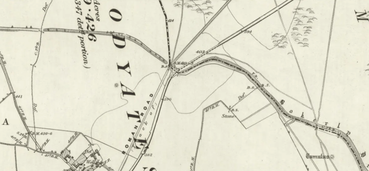
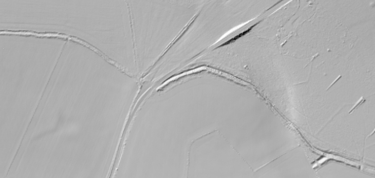
The Romans entered ‘Dorset’ by cutting their road straight through the ancient earthwork of Bokerley Ditch. Stretching across the chalk landscape on what is now the Dorset border, Bokerley probably had its origins in the Bronze Age or Early Iron Age, but was altered, enlarged and reused over many centuries. Together with neighbouring linear earthworks, including Grim’s Ditch, and surrounded by the Dorset Cursus, barrows and other prehistoric remains, it forms part of an extraordinary ancient landscape.
Its original purpose remains uncertain. Rather than simply being a defensive fortification, its earliest form may have marked an important territorial or cultural boundary, dividing communities whose patterns of settlement and land use differed on either side. Over time, however, Bokerley became increasingly formidable. By the later Iron Age and Roman periods, parts of the earthwork appear to have taken on a much more defensive role.

When Ackling Dyke was constructed, the Roman road from Sorviodunum simply crossed this ancient boundary and continued south-westwards. But remarkably, the relationship was later reversed. During the late Roman period Bokerley was strengthened and extended, and phases of the earthwork actually blocked the Roman road. Shortly after AD 364, after one major defensive phase, the road was reopened, before an even later phase, probably after AD 393–395, cut across it again. This time, the road appears to have remained blocked.
By then, this was no empty frontier. Excavations around Bokerley Junction revealed a substantial Romano-British roadside settlement, with pits, hearths, burials, a corn-drying oven and ditched enclosures. Occupation was concentrated between around AD 275 and 400, and more than 1,200 Roman coins were recovered, most dating to the 4th century. Their sheer number has even led to suggestions that a market or shrine may have stood here.

Bokerley’s importance did not disappear with the end of Roman rule. The great earthwork continued to form a significant boundary in the post-Roman landscape and has long been discussed in relation to delaying the westward expansion of Anglo-Saxon settlement. Bokerley demonstrates the extraordinary longevity of a boundary which remained meaningful long after the people who first dug it had disappeared.
Bokerley Ditch is still a substantial earthwork today. In places it reaches around 25–34 metres across, with the bank standing up to around 3 metres above the bottom of its ditch. Its survival owes much to the long history of Cranborne Chase and the comparatively undeveloped landscape around it, although agriculture has levelled sections over the centuries. After three thousand years of use and alteration, Bokerley Ditch still performs one of its oldest functions by forming part of the modern boundary between Dorset and Hampshire.
At Bokerley Junction, where Ackling Dyke crosses the ancient boundary close to the modern A354, there is now a large lay-by, occasionally accompanied by a refreshment van. Considering that a busy Romano-British roadside settlement stood around this very junction nearly 2,000 years ago, stopping here for food beside the road is not so modern after all.
For walkers, the safest way to begin following Ackling Dyke is to trace Bokerley Ditch before veering towards Penbury Knoll, then dropping down to join the route around Oakley Down. This avoids walking along the A354, which follows the Roman road for the first part of its course.
Grim’s Ditch
Grim’s Ditch is something of an enigma. Far less imposing than neighbouring Bokerley Ditch, it nevertheless stretches much further across the landscape, although centuries of ploughing and agriculture have reduced or completely erased large sections. Tracing its surviving and former course across Cranborne Chase reveals just how extensive this ancient earthwork once was, nevertheless, it may not have been one consistent boundary.
Its date and purpose remain uncertain. Grim’s Ditch is thought to have prehistoric origins, probably within the Bronze Age or Early Iron Age, although, like so many ancient boundaries, it was almost certainly altered, strengthened, reduced and reused at different times along its course. Surviving sections consist of a substantial bank and ditch, forming part of a much larger system of linear earthworks crossing the Chase.
Exactly what it was for is harder to establish. Defensive, territorial and agricultural explanations have all been suggested, and different sections may not necessarily have served the same purpose throughout their long history. Rather than being a single defensive barrier, it may have helped divide and organise the landscape, defining territories, settlements, grazing land or routes of movement.
Its relationship with the surrounding prehistoric landscape is equally complicated. Grim’s Ditch passes amongst barrows, settlements and other earthworks, while its course appears to form a huge circuit around part of the Chase. Its relationship with Bokerley Ditch is also uncertain, with both monuments altered over such long periods that establishing which elements came first is difficult.
For a short distance in the west, the later Roman road appears to follow the same line as Grim’s Ditch. This may be little more than coincidence, or the Roman engineers may simply have made use of an existing alignment where it happened to suit their route. Either way, Ackling Dyke soon strikes away again on its direct course across the Chase.

The A354
Today the busy A354 carries traffic between Blandford and Salisbury across Cranborne Chase, but for a short distance around Woodyates and Bokerley it follows Ackling Dyke itself. Here the turnpike road was laid over the Roman route before striking away again past the great barrow cemetery at Oakley Down.

The road belongs to another major change in how people moved across this landscape. Before the turnpike era, older medieval routes threaded through the valleys and hunting grounds of the Chase, many radiating from Cranborne, its former administrative centre. Traces of these old ways can still be followed, while the surviving packhorse bridge at Tarrant Monkton marks the route of an old road through the Tarrant Valley towards Blandford.
The turnpike instead offered travellers a more direct route across the higher, open ground. But improved roads brought opportunities for less welcome travellers too. The lonely expanses of Cranborne Chase, crossed by tracks and holloways into which a rider could quickly disappear, became ideal country for highwaymen and smugglers.
Local tradition places the mysterious Tarrant Highwayman amongst the valleys and downs immediately to the south. Known only as Tom, he was said to haunt the old routes through Tarrant Gunville, Hinton, Monkton, Keyneston and Crawford, robbing wealthy travellers crossing the downs between Blandford and Cranborne Chase.
It was also the country of Isaac Gulliver, the notorious 18th-century smuggler. In 1768 he married Betty Beale, daughter of William Beale, landlord of the Blacksmith’s Arms at Thickthorn Farm, directly beside the Blandford–Salisbury road. Gulliver later took over the inn himself, renaming it the King’s Arms, while developing a smuggling network which stretched from the Dorset coast deep into the countryside. The older tracks crossed Cranborne Chase towards Cranborne, Wimborne and the coast, providing routes where contraband which had landed in Poole and the neighbouring coast could be carried inland by horse, cart or on foot. The later turnpike created the powerful Blandford-to-Salisbury line we recognise today, obscuring something of that older relationship between the Chase and the coast.

Penbury Knoll
Topped today by a distinctive crown of trees, Penbury Knoll rises prominently above Pentridge Hill, overlooking the route of Ackling Dyke. The knoll is generally described as a small prehistoric hillfort or enclosure, covering around 1.7 hectares (just over 4 acres), but even its date is debated. The Dorset Historic Environment Record describes it as an Iron Age univallate hillfort, possibly unfinished, while Historic England suggests it could have much earlier origins, potentially dating back to the Neolithic period. Its surviving bank and partial outer ditch are slight in places, with a large gap on the eastern side and no definite entrance identified. Later quarrying has further disturbed the site.

Mesolithic and Neolithic worked flint and Portland chert have been found here, including microliths, axes, scrapers, blades and other tools. These finds do not necessarily date the enclosure itself, but show that people were using Penbury Knoll thousands of years before the Romans drove their road through the landscape below. The knoll also sits amongst an extensive system of prehistoric and Romano-British fields, with substantial surviving lynchets surrounding the hill. Whether Penbury was a defended settlement, an earlier enclosure, an unfinished hillfort or something that changed purpose over time remains open to debate.
Centuries later, documentary evidence records a beacon on Penbury Knoll during the Tudor period, and it appears as No. 22 in H. T. White’s later schedule of Dorset beacons. Penbury therefore appears to have formed part of a much wider network of prominent hills from which warning signals could potentially be passed across the county.

The Dorset Cursus
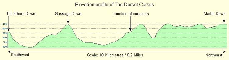
In the landscape west of Pentridge lie the mainly hidden remains of one of Britain’s most extraordinary prehistoric monuments. The Dorset Cursus stretches for almost 7 miles (10 km) across Cranborne Chase, making it the longest known cursus in Britain – around three times the length of the Greater Cursus at Stonehenge.
Constructed during the Neolithic period, probably between about 3400 and 3000 BC, it consisted of long, roughly parallel banks and external ditches defining an enormous narrow enclosure across the landscape. Today much has been flattened by centuries of agriculture, making its true scale difficult to appreciate from the ground, but aerial photography, excavation and geophysical survey have allowed much of its course to be reconstructed.
It was not necessarily constructed as a single monument. The southern Gussage Cursus ran from Thickthorn Down towards Bottlebush Down, while the Pentridge Cursus continued north-east towards the later Bokerley Ditch. Differences in their construction and alignment suggest that the two sections may originally have been separate monuments before being joined to create the enormous cursus we recognise today.
The cursus encountered earlier Neolithic long barrows, with its course apparently deliberately referencing some of them. Around Bottlebush Down and Gussage Down, one section has been interpreted as creating a monumental route associated with the dead, including an alignment towards the midwinter sunset. Whatever its precise meaning, this was clearly far more than a convenient way of travelling from one place to another.
Its purpose remains unknown. The word cursus is Latin for a course or racetrack, a name introduced by the antiquarian William Stukeley in the 18th century when monuments of this type were mistakenly interpreted as Roman racecourses. Today they are understood to be thousands of years older. Ceremonial or processional uses have been suggested, particularly because of their relationships with burial monuments, although exactly what took place within them is something archaeology has yet to explain.
The cursus eventually faded from use, but its presence continued to influence the landscape. Later prehistoric barrows and cemeteries were constructed around it, while generations continued to live, farm and bury their dead amongst its slowly eroding banks.
Ackling Dyke crosses the Dorset Cursus almost at right angles. The road simply continued straight over a monument that had already occupied Cranborne Chase for more than three thousand years.



Oakley Down
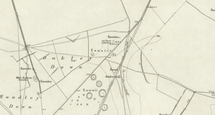
Beside Ackling Dyke lies Oakley Down, an extensive Bronze Age cemetery of around 30 recorded barrows, including bowl, bell and disc barrows. On the slopes beyond stands the much earlier Neolithic long barrow of Wor Barrow, later famously excavated by Pitt-Rivers and transformed into something of an archaeological amphitheatre for his paying guests.


Several of the Oakley Down barrows were opened by William Cunnington and Sir Richard Colt Hoare in the early 19th century, revealing cremations and burials accompanied by objects including pottery, bronze daggers, flint arrowheads, amber and other personal ornaments. Since then, much of the cemetery has largely been left undisturbed.

When the Romans arrived, they showed considerably less respect for this ancient burial ground. Ackling Dyke cuts directly through the cemetery, even slicing through one of its barrows.




Bottlebush Down
Ackling Dyke next crosses Bottlebush Down, another landscape crowded with the remains of people who were here long before the Romans. Barrows are scattered across the down and into Salisbury Plantation, amongst the remnants of extensive prehistoric field systems, banks and boundaries which once spread for miles across this part of Cranborne Chase. The great Dorset Cursus also passes across Bottlebush, leaving different generations of earthworks overlapping one another before the Roman road added yet another line.
One particular barrow is said to sing. It is not the only Dorset burial mound with this peculiar reputation: the Music Barrow near Bincombe carries a similar legend. At Bottlebush it was said that if you sat quietly upon the mound at midday, you might hear the sound of fairy music coming from within.
During the winter of 1927–28, Dr R. C. C. Clay, an antiquary and archaeologist, was driving from Cranborne towards Handley when he saw a horseman travelling across the down beside him. At first Clay assumed he was connected with the nearby training stables, until the rider drew closer. He described a bare-legged figure wearing a long loose garment, riding apparently without bridle or stirrups. The horseman suddenly galloped alongside the road before turning away and ultimately disappearing from view near one of the ancient mounds. Clay later gave his own account of the encounter to archaeologist and folklorist Leslie Grinsell. A few years later, another story emerged of two girls cycling nearby who believed they had been chased by a frightening horseman, apparently unaware of Clay’s earlier experience.


Gussage Down
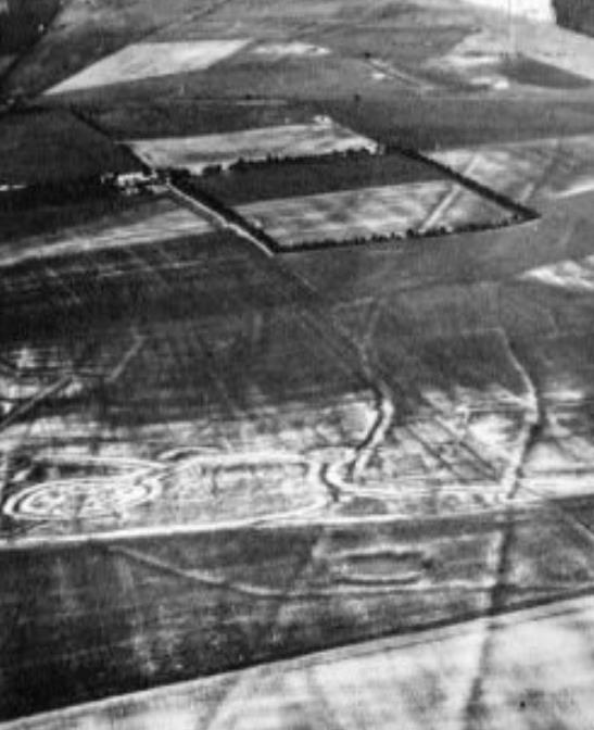
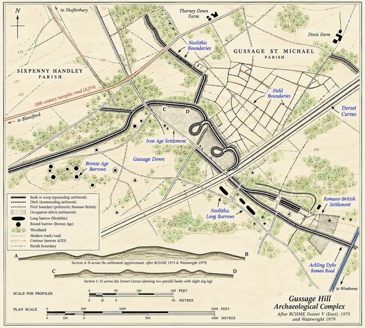
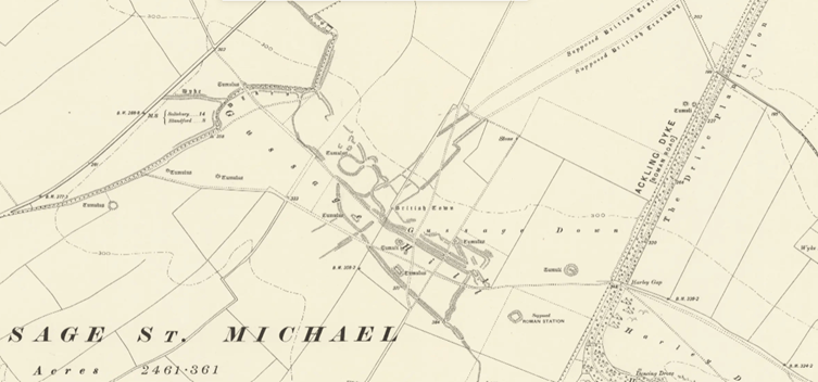
Gussage Down is an extensive multi-period archaeological landscape, incorporating Neolithic long barrows, Bronze Age round barrows, ancient field systems and linear boundaries alongside a substantial settlement complex dating principally from the Middle and Later Iron Age. It became one of the largest known native occupation sites in Dorset, with some of its boundaries and enclosures apparently remaining in use until around the time of the Roman conquest.


A series of banks and ditches divided the landscape into different areas, while smaller enclosures may have been used for controlling or keeping livestock. Evidence of occupation survives as spreads of dark soil and archaeological material which can still appear beneath the plough.
Close to the line of Ackling Dyke lies a second concentration of occupation material containing predominantly later Romano-British pottery. Its position suggests that activity shifted towards, or developed beside, the new road as it adapted to the new route carrying people, animals and goods across Cranborne Chase.
When Sir Richard Colt Hoare surveyed Gussage Down in the early 19th century, considerably more of its earthworks remained visible. Since then cultivation has levelled or damaged much of the site, making the sequence of its many enclosures, boundaries and settlements increasingly difficult to unravel from the surviving earthworks alone.

(Image amended from BHO)




Knowlton
Just over 2 miles east of Ackling Dyke sits one of Cranborne Chase’s great archaeological surprises. Knowlton is not just a single monument, but a complex of late Neolithic ceremonial earthworks, including several henges and associated burial monuments. At its heart stands the extraordinary ruin of Knowlton Church, built during the 12th century directly inside one of the prehistoric henges. The combination is often presented as a simple transition from pagan to Christian worship, although the reality may be more complicated. When the church was built, the henge was already thousands of years old. Whether its builders deliberately chose an ancient sacred place or simply reused a conspicuous enclosure cannot be known, but the result is a unique example of successive generations claiming and reshaping the same piece of landscape for very different beliefs.
Nearby are the Northern Circle, Southern Circle and the earthwork traditionally called the Old Churchyard, while immediately east of the church lies the enormous Great Barrow, one of the largest round barrows in Dorset. From ground level it is surprisingly difficult to appreciate the scale of the whole site; from the air, the concentration of circles, banks and burial mounds becomes much clearer.
The medieval church served a small settlement beside the River Allen, around 500 metres to the west, which subsequently disappeared. The church itself had fallen out of use by the 17th century. Local legend claims its famously beautiful bells were stolen by men from Sturminster Marshall, who dropped them into the River Stour while escaping across White Mill Bridge. Every attempt to recover them supposedly drove them deeper into the mud, where folklore insists they remain today.
Knowlton has never entirely lost its association with belief. Stories of phantom riders, cloaked figures and other apparitions surround the ruined church, while ribbons, messages and offerings are still tied amongst the nearby yew trees. Whatever we make of those traditions, people continue to treat this ancient landscape as somewhere different.


Gussage St Michael and Long Crichel
Until now Ackling Dyke has largely held to the higher chalk ground, but around Gussage St Michael the road begins to encounter a different landscape. Here it descends into the shallow valley and crosses Gussage Brook, the chalk stream which flows through the Gussages before eventually joining the River Allen farther downstream. It is worth remembering that the watercourse we see today may not perfectly represent the one encountered by Roman travellers. These are chalk-stream valleys, strongly influenced by groundwater, and their flow can vary considerably. When trying to understand the route of an ancient road, today’s streams, wet ground and apparently insignificant valleys cannot automatically be assumed to have behaved in exactly the same way two thousand years ago.


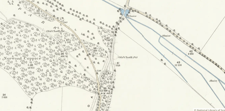
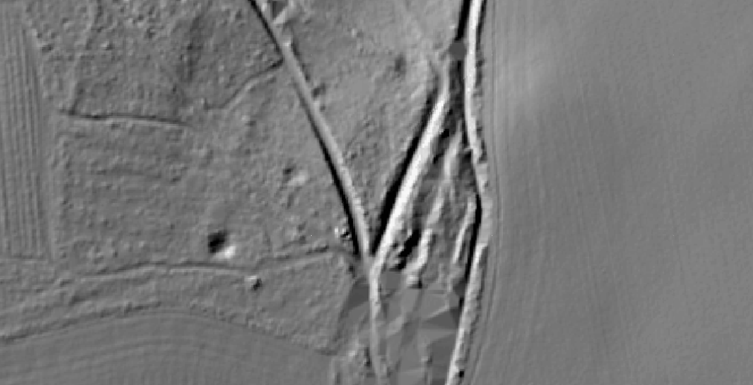
Ackling Dyke then climbs out of the Gussage valley and onto Sovell Down, where its course is interrupted by later quarrying. Having crossed the down, the road descends into a second and quite separate valley. This time it encounters the Crichel Stream, a winterbourne running through Long Crichel and Moor Crichel before eventually joining the River Allen. As Ackling Dyke approaches the valley, a later route converges with its line, the two apparently sharing the same corridor before separating again at the water. The Roman alignment crosses the stream at a ford, where a footbridge now also marks the crossing.


On the climb out of the Crichel valley, the Roman road becomes strikingly visible again. Here the agger rises prominently from the hillside, accompanied by its roadside ditches. The later track does not always remain on top of the Roman road but begins to use the ground alongside it, in places apparently following the ditch itself. Perhaps this was simply the easier route. Once regular maintenance ceased and the Roman metalled surface began to break apart, the high, increasingly rough agger may have become awkward for horses and carts, while centuries of traffic gradually established an easier line beside it.
Before Ackling Dyke disappears once more beneath cultivated ground, another later track cuts directly through the agger, leaving a clear slice through the Roman earthwork.



Moor Crichel and Manswood
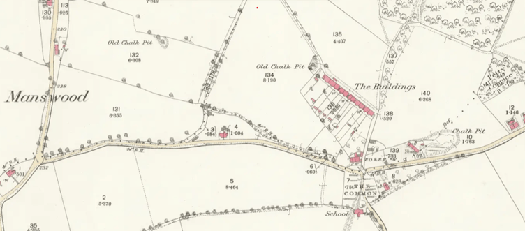
Having climbed out of the Crichel valley, Ackling Dyke skirts Moor Crichel, its later landscape dominated by the Crichel estate and its great avenues of trees, before continuing south towards Manswood. Here the survival of the Roman road becomes increasingly changeable. In places the agger can still be followed, only to disappear completely beneath cultivated fields.

At Manswood, known for the extraordinary length of thatch covering its historic terrace of cottages, Ackling Dyke again vanishes into the fields and instead a later track runs roughly parallel to its course, wandering alongside the much straighter Roman alignment rather than faithfully following it. In contrast, the next section of the Roman road becomes a road once more as its alignment is absorbed into the modern country lane past Witchampton.


Badbury Rings rises directly ahead, its wooded summit dominating the approaching landscape. The view would almost certainly have been very different in the Roman period. The dense woodland, which now crowns and surrounds Badbury, is comparatively recent, introduced by the Bankes of Kingston Lacy Estate, and the great Iron Age earthworks would have been a much more conspicuous landmark on the horizon.

After a slight change of alignment, the surviving route begins its gradual approach towards Badbury. Here the modern track appears to follow alongside the Roman agger, close to its southern roadside ditch, rather than travelling directly over its crest. Once again, the Roman engineering has influenced the routes which followed without necessarily remaining the surface people actually travelled upon.




Badbury Rings
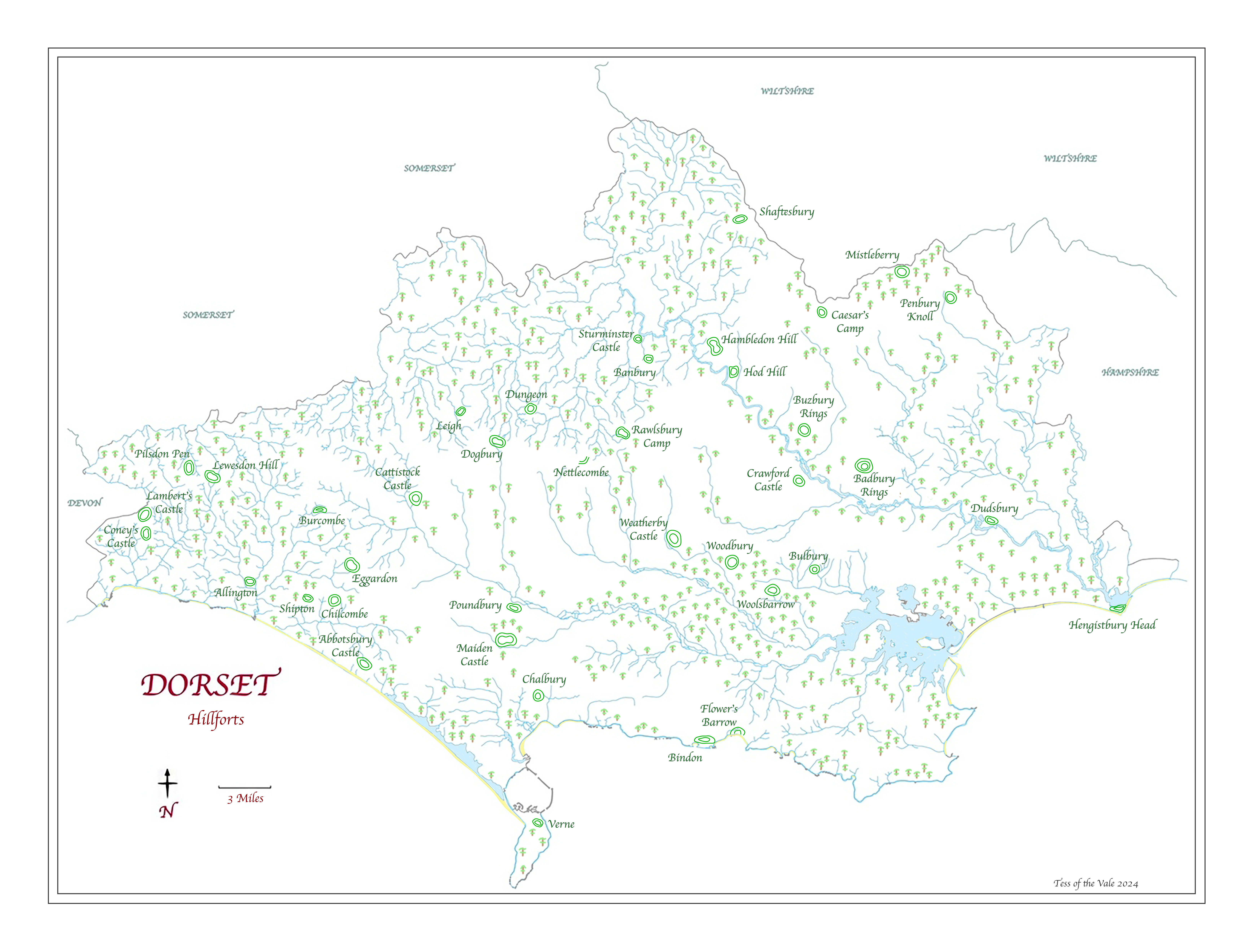
After more than twenty miles across Cranborne Chase, Ackling Dyke finally reaches Badbury Rings. Yet the Roman road was only the latest route to arrive in an already ancient landscape. Three Bronze Age burial mounds survive beside the approach, part of a much wider prehistoric cemetery. Across the Kingston Lacy estate more than 100 Bronze Age barrows have been recorded. Some of the burial mounds here were already ancient when the hillfort itself was constructed.

Dominating everything is the great multivallate Iron Age hillfort, occupying around 16.5 hectares of a prominent chalk knoll. Its innermost defences probably originated around the 6th century BC and were subsequently enlarged until three enormous circuits of banks and ditches surrounded the summit. By the Late Iron Age this was Durotrigian country, part of the same broad tribal territory containing great hillforts such as Maiden Castle, Hod Hill and Hambledon Hill the latter two part of a chain sitting along the River Stour.
Ackling Dyke doesn’t really end at Badbury Rings, it arrives at a crossroads. The archaeology around the junction is complicated. Late Iron Age occupation continued into the Roman period, while excavations and aerial photography have revealed settlements, enclosures and later Roman activity around Badbury. One site immediately south-west of the hill produced Roman coins and pottery spanning the Late Iron Age into the fifth century and has at different times been interpreted as a temple and associated with Vindocladia.
That larger settlement makes the story even more interesting. Excavations have revealed Iron Age pits and post-holes beneath and beside the later Roman road, showing that Roman development was imposed upon an existing occupied landscape. Farther south-west, another substantial enclosure once thought to be an early Roman military fort has now produced predominantly fourth-century evidence, suggesting that the Roman landscape around Badbury continued to change surprisingly late in the occupation.

From the summit, the reason for Badbury’s importance becomes obvious. To the north and east stretches Cranborne Chase, the landscape Ackling Dyke has just crossed, crowded with the remains of barrows, settlements, fields, dykes and ceremonial monuments. To the west lies the Stour valley and beyond it the route towards Roman Dorchester; to the south the landscape opens towards Poole Harbour and the coast.
For thousands of years, Badbury had been somewhere people approached. Bronze Age communities buried their dead around it. Iron Age people enclosed its summit behind monumental ramparts. Roman engineers brought roads towards it from several directions. Settlements subsequently developed around those routes.
The Roads
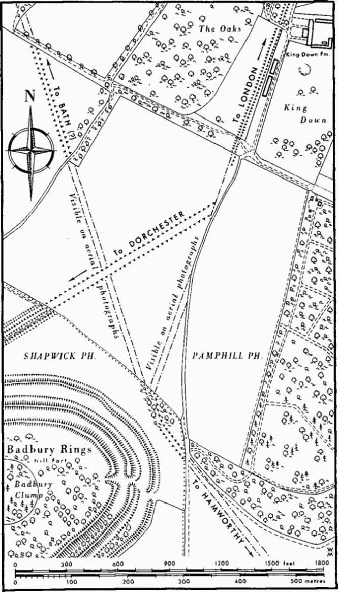
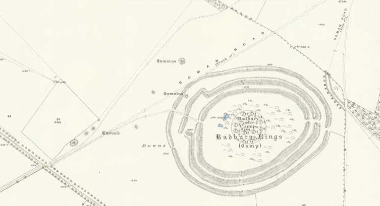
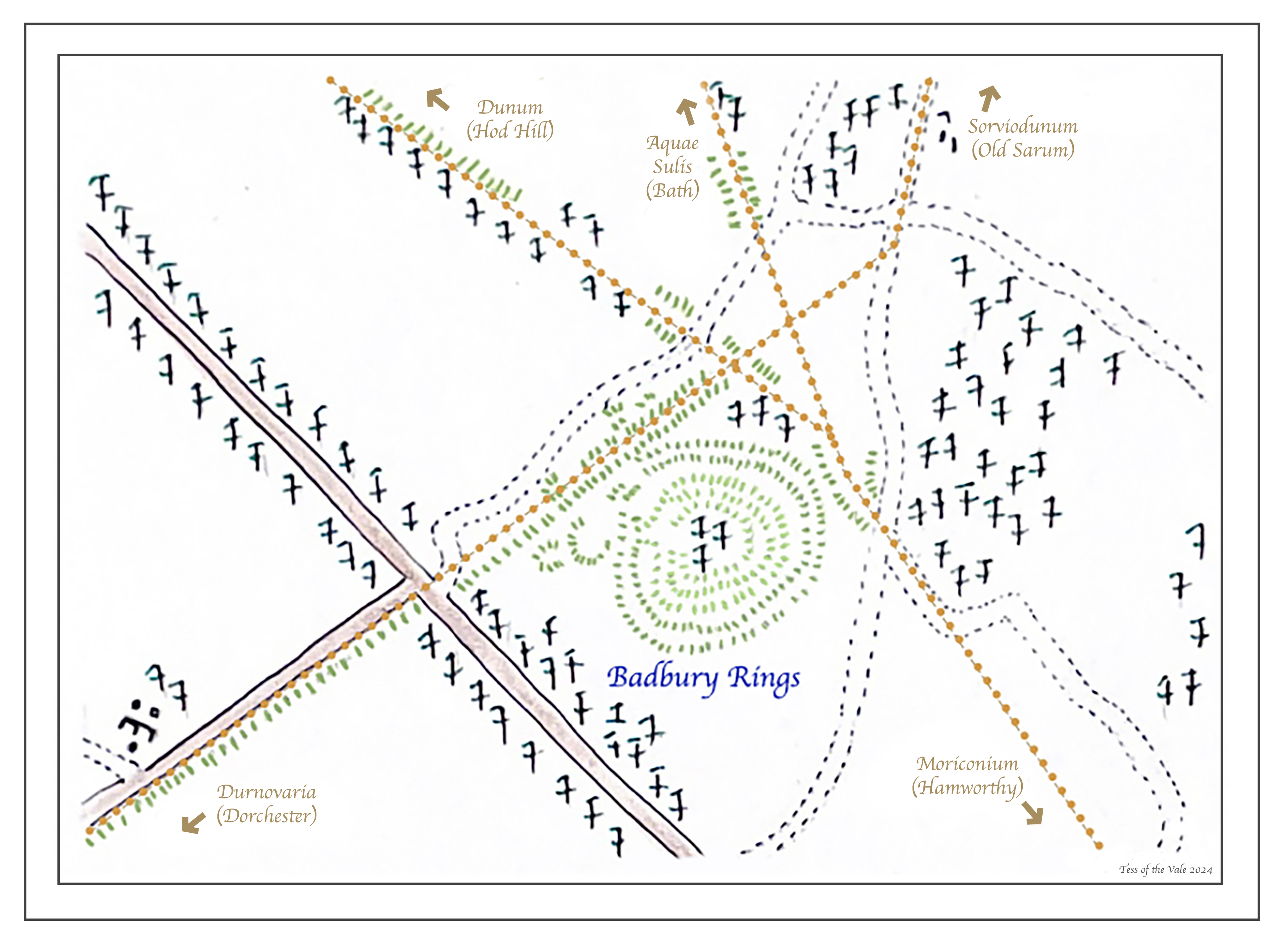
Five Roman roads converged immediately north of the Rings, creating one of the most remarkable ancient road junctions in Dorset. Roads radiated away towards Dorchester, Bath, Hod Hill and the harbour at Hamworthy, connecting the hill and the settlements around it with destinations across Roman Dorset and beyond.
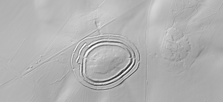
Much of this network has now disappeared beneath fields and later roads, but it has not vanished entirely. Sections survive as raised earthworks, old field boundaries, tracks and lines of trees preserve their alignments, while aerial photography, cropmarks and LiDAR reveal routes which are almost impossible to recognise from ground level. The junction itself is particularly clear from the air, where the roads from Old Sarum, Dorchester, Bath and Hamworthy can still be traced converging and crossing immediately north of the hillfort.
However, they were not necessarily all constructed at the same time. Where the Dorchester road crosses the Bath road, aerial evidence suggests that the Bath route was already there when the Dorchester road was laid across it. The great junction at Badbury was therefore not one single Roman engineering project, but a road network which developed and changed over time.

Roman Road to Bath – Aquae Sulis
From the junction north of Badbury Rings, a Roman road heads north towards Aquae Sulis, modern Bath. It initially follows the higher ground above the Tarrant Valley, passing the villages of Tarrant Monkton, Tarrant Launceston and Tarrant Hinton while generally avoiding the wetter ground beside the river below.
North of Tarrant Hinton, on the western side of the Roman road, between its course and the prehistoric Pimperne Long Barrow, lies the site of a Roman villa. Directly opposite, on the eastern side of the road, are the remains of an earlier Iron Age settlement. The road therefore passes between the two very different phases of occupation of a community established before the Roman conquest on one side and a substantial Romano-British site on the other.
Continuing north, the road passes through the Eastbury landscape and towards Tarrant Gunville. Here its ancient alignment becomes incorporated into later farm tracks, allowing sections of the Roman route to remain remarkably easy to follow despite the disappearance of the original engineered surface.
Beyond Tarrant Gunville it continues onto the higher chalk ground around Chettle, skimming close to Chettle Long Barrow, another monument which had already stood in this landscape for thousands of years when the Roman road arrived. Nearby lies the earthwork traditionally known as Caesar’s Camp; despite the wonderfully Roman-sounding name, that attribution should be treated cautiously, and its actual date and function need separating from later antiquarian tradition.
The road then continues northwards across the high chalk towards Win Green, where it leaves Dorset and enters Wiltshire. From there its journey continues through the wider Roman road network towards Aquae Sulis, linking Badbury and the settlements of Dorset with one of Roman Britain’s most important religious and urban centres.
Roman Road to Hod Hill – Dunim
From the junction north of Badbury Rings, another possible Roman route heads north-west towards Hod Hill, where a Roman fort was later constructed inside the great Iron Age hillfort. Unlike Ackling Dyke, however, much of this road has almost disappeared from the modern landscape and its precise course is not always certain.
Leaving Badbury, its proposed line is initially preserved by an extraordinarily straight parish boundary and belt of trees, pointing directly towards Hod Hill in the distance. The alignment has long been interpreted as part of the Roman road, although excavation along the boundary failed to uncover a road surface, so its identification should remain cautious.
Beyond this, the route crosses the high ground later occupied by RAF Tarrant Rushton. Construction of the huge wartime airfield dramatically altered the plateau and makes the ancient landscape particularly difficult to reconstruct. On the far side, however, the suggested Roman alignment reappears in straight tracks and field boundaries as it descends towards the River Tarrant.
Here an old ford provides an intriguing possible crossing point. The ford itself cannot presently be proved Roman, and may be considerably older or later, but it sits directly upon the projected line between Badbury and Hod Hill. If the Roman road followed this alignment, this is approximately where it would have had to negotiate the river before beginning its climb onto the chalk hills beyond.
Climbing away from the Tarrant, the route passes close to Buzbury Rings. Once regarded principally as an Iron Age defended settlement, geophysical and LiDAR survey has revealed something much older beneath it: a Neolithic causewayed enclosure, one of the rarest types of prehistoric monument in Britain. The D-shaped enclosure was subsequently incorporated into a site which continued to develop through later prehistory, eventually becoming the defended Iron Age settlement whose earthworks remain visible today.
Beyond Buzbury its course becomes increasingly difficult to trace, and somewhere across the country towards Blandford it must also have negotiated the River Stour before eventually reaching Hod Hill. There, the destination is unmistakable as another enormous prehistoric hillfort, this time containing the remains of an early Roman fort within its ramparts.


Roman Road to Dorchester – Durnovaria
From the great junction north of the Rings, another Roman road heads south-west towards Durnovaria — Dorchester. Intriguingly, where it crosses the earlier Bath road, aerial evidence suggests the Bath route was already there, showing that Badbury’s Roman road network developed in stages rather than as a single scheme.
The road skirts the northern side of Badbury before heading towards Shapwick. Here the modern road roughly follows its course into the village, where traces of early Roman occupation have been found. Immediately south of St Bartholomew’s Church, the Roman alignment crosses the River Stour. On the opposite side it continues straight across the floodplain as a low agger where an excavation in 2012 found a layer of flint nodules forming the base of the Roman road beneath the floodplain. Whether the Stour itself was crossed by a ford, bridge or some combination of engineered causeway and crossing is less certain.
Beyond the Stour, cultivation has erased much of the road from the surface, although its remarkably straight course survives in aerial photographs, field boundaries, lanes and occasional pieces of agger as it travels through Sturminster Marshall, Winterborne Zelston and Winterborne Kingston. Old field names including Greatstreet and Kingsway even preserve a memory of the vanished route. It also cuts through another ancient Ditch, similar to Bokerley, known as Combs Ditch.
Farther west the road becomes spectacularly visible again through Puddletown Forest and Thorncombe Wood. Here surviving aggers and roadside earthworks preserve the route, while an excavated section in Thorncombe Wood revealed a gravel road surface with hollows interpreted as wheel ruts. Interestingly, in Puddletown Forest the engineers abandoned absolute straightness and made a sharp deviation to avoid a steep-sided hollow before returning to their original south-westerly alignment.
Finally, it descends Stinsford Hill towards the Frome valley and Roman Dorchester. Surface evidence becomes elusive here, but a probable Roman milestone survives beside the alignment and a possible Roman ford or bridge was reportedly discovered in the river bed during the 19th century.


Roman Road to Hamworthy – Moriconium
From Badbury, another Roman road heads south towards Poole Harbour and Hamworthy, connecting the great road junction with the coast. Unlike some of the later routes radiating from Badbury, this road may have its origins in the earliest years of the Roman conquest, when the army was advancing into Durotrigian territory.
Its first major destination was Lake Farm, near Wimborne. Once thought to be a relatively small Roman fort, geophysical survey by Bournemouth University has revealed a much larger legionary fortress, established during the mid-AD 40s and associated with Legio II Augusta. At this time the legion was commanded by the future emperor Vespasian, who was campaigning through southern Britain. Archaeologist Miles Russell has suggested that one of the substantial buildings identified within the fortress may even have been Vespasian’s residence while commanding the campaign, while Lake Farm itself has been proposed as the possible location of the early legionary base Isca.
Before reaching Lake Farm, however, the road had to negotiate the River Stour. The precise Roman crossing has been lost, but at Eye Mead, Pamphill, part of the approach survives as a raised, flat-topped causeway crossing the low-lying ground. Elsewhere around Pamphill the road remains surprisingly tangible, with sections of its earthwork surviving amongst the trees of Abbot Street Copse.
Beyond Lake Farm the road continued south through Corfe Mullen and Upton towards Hamworthy, on the edge of Poole Harbour. Much has disappeared beneath later roads and modern development, but its line has proved remarkably persistent. Tracks and paths preserve sections of it around Corfe Mullen, while farther south later roads have absorbed parts of the Roman alignment on the approach to Hamworthy.
Poole Harbour provided access to the sea, linking the inland road network with maritime movement, trade and supply. Hamworthy is traditionally associated with the Roman name Moriconium, although that identification remains uncertain.

Kingston Lacy
Much of the landscape surrounding Badbury Rings later became part of the great Kingston Lacy estate, home of the Bankes family from the 17th century. Although the house itself lies some distance from the Roman road, the estate eventually encompassed Badbury Rings and a remarkable concentration of the prehistoric and Roman archaeology surrounding it.
Its long history as a privately managed estate also helped protect parts of this landscape from the intensive development experienced elsewhere. Badbury remained in private ownership with relatively restricted public access until the later 20th century, while woods, parkland and agricultural ground preserved stretches of Roman road, barrows, earthworks and ancient boundaries across the estate.
The Bankes family were also interested in the antiquities around them. William John Bankes, the great traveller and collector who inherited Kingston Lacy in 1834, filled the house and grounds with antiquities brought back from his travels, while the archaeology lying beneath his own Dorset estate was gradually being recorded by antiquarians and, later, archaeologists.
When Ralph Bankes died in 1981, Kingston Lacy and its extensive estate, including Badbury Rings, passed to the National Trust. Today the Trust manages not simply the house and gardens but a much older archaeological landscape surrounding them, including Bronze Age burial mounds, Badbury’s Iron Age ramparts and surviving sections of the Roman roads which once converged beside the hill.

Vindocladia
For generations the Roman name was associated rather loosely with Badbury Rings itself, but recent archaeology has begun to separate the different elements of this remarkable landscape.
Badbury was the ancient Iron Age hillfort. The great Roman road junction developed immediately beside it. A smaller Late Iron Age and Romano-British settlement also occupied the ground immediately south-west of the Rings, where excavations produced Durotrigian and Roman coins, pottery, glass beads, bronze pins, a bracelet and brooch, stone roofing slabs and painted wall plaster. Occupation here continued into the 5th century.
But around two kilometres farther south-west, immediately north-east of Shapwick, archaeologists have subsequently discovered something considerably larger. Fieldwalking, excavation and extensive geophysical survey have revealed an Iron Age settlement which continued to develop throughout the Roman period, eventually covering at least 23 hectares and probably extending beneath part of the present village. Today the National Trust considers this substantial roadside town the more likely candidate for Vindocladia, the settlement recorded in the Antonine Itinerary.
Its position makes perfect sense. The settlement developed alongside the Roman road from Badbury towards Dorchester, close to its crossing of the River Stour at Shapwick. It was not simply something the Romans dropped onto an empty landscape: excavation revealed earlier Iron Age settlement beneath the Roman town, while later Roman development included substantial buildings and eventually a fortified enclosure across part of the site.
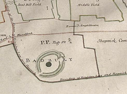
Between the town and Badbury lies another clue to its importance. Beside the Dorchester road is a large, roughly circular earthwork, around 80 metres across, identified as an amphitheatre on an estate map as early as the 18th century. Its interpretation remains uncertain, but its position resembles amphitheatres at places such as Dorchester and Silchester. When archaeologists investigated it in the 1980s they questioned why the apparently small settlement then known at Badbury would require such a public building. The subsequent discovery of a much larger Roman town only a short distance away makes that question considerably more interesting.
Even its name may preserve something of its appearance. Vindocladia has traditionally been interpreted from Brittonic elements associated with white or bright and a ditch or earthwork. If that interpretation is correct, it is tempting to look at the chalk beneath our feet. Freshly cut banks and ditches surrounding the settlement would have gleamed white across the landscape. We cannot know whether that is what Roman travellers actually saw or what the name originally described, but in this chalk country the possibility is appropriate.
Today almost nothing of this substantial settlement survives above ground. Badbury Rings still dominates the skyline, while the Roman town beside its road has virtually disappeared beneath the fields.