
Venture through the historic village of Monkton Combe, uncovering layers of its industrial past. From the school, mill, lock-up and church, follow the route of the lost canal towards Tucking Mill. Climb up to the top of the viaduct, once part of the Somerset and Dorset railway, and step into one of the longest tunnelled footpaths in the country. Emerge back into the light to skim the edge of the Georgian city of Bath. Explore churchyards and a crumbling chapel to discover the landscaped garden of Prior Park. Here, the iconic Palladian Bridge sits quietly in its own combe, creating a scene familiar to fans of the Netflix series ‘Bridgerton‘. The path then rises up Claverton Down, where quarries once scattered the ground, to views over Bath and the viaduct at Limpley Stoke. Drop steeply down the hill to return to Monkton Combe, with its old mill chimney still rising from the vale.

Distance: 5 miles/8km – with extra options to explore Monkton Combe, Bath Abbey Cemetery and Prior Park
Time: 2-3hrs
Ability: Easy.
Max height: 556ft
Min height: 125ft
Total climb: 682ft
Terrain: Tracks, paths, fields, roads and a tunnel.
Start Point: Monkton Combe Village Hall Car Park (Postcode: BA2 7HF, Grid Reference: ST772619, What Three Words: neck.noises.royal).
Map: OS Explorer 142 Shepton Mallet and Mendip Hills East
How to get there: Leave Shaftesbury on the A350, traveling north to Warminster. Merge onto the A36 and stay on the same road for the next 10 miles or so. Turn left after crossing the Limpley Stoke Viaduct and then left onto Church Lane. Head straight through the village of Monkton Combe and around the sharp right hand bend to find the car park on the right.
Dogs: On leads where livestock is present and in accordance with any notices on the walk and The Countryside Code.
Refreshments: If open there is a National Trust café in Prior Park or just off the route in Monkton Combe is the Wheelwrights Arms and in Combe Down is The Hadley Arms.
Related Walks: Dorset Railways, Stourhead, Dorset on Film, and Bridges, Viaducts and Tunnels.

Walk
Deep within the folds of the hills, south of the city of Bath, sits the small village of Monkton Combe. The settlement lies in a secluded valley carved by the streams that wind through the landscape before joining the River Avon. Along the valley floor runs the gentle Midford Brook, its waters flowing quietly past the cottages and old industrial sites that tell the story of the village’s history.

The village was originally known simply as Combe, a name that describes its setting. ‘Combe’ or ‘coombe’ means a steep-sided valley, derived from the Old English cumb, or an even older Brythonic origin, the Welsh word cwm. Long before the village appeared, the valley formed the western end of the defensive earthwork known as Wansdyke, a massive boundary thought to have been built to protect this region from Saxon invaders. By the Anglo-Saxon period the valley was settled and cultivated. The land was granted, not by a Norman ruler, but by an English king to the Benedictine monks of Bath Abbey. During the medieval period the village adopted the additional name ‘Monkton’, marking its ownership by the abbey and distinguishing it from the many other ‘Combes’ scattered across the West Country.
Centuries later, the quiet valley experienced a brief industrial awakening. In the late eighteenth century nearby mining, and the opening of the Somerset Coal Canal in 1800, brought new activity and a growing population. Houses were built from the warm local Bath stone along the valley to accommodate workers. By 1910 the canal had been converted into a railway line, giving the village a short-lived station and briefly tying this secluded place into the wider industrial network of the region.
Today much of the village and its surrounding fields belong to Monkton Combe School. Founded in 1868 by the first vicar of the parish, the Revd. Francis Pocock, the school quickly became the dominant presence in the valley. In truth, what appears to be a traditional rural village is, in large part, a school community. Many of the houses are school boarding houses or homes for members of staff, giving the settlement an atmosphere quite unlike most English villages.

At the top of Mill Lane stands the Wheelwrights Arms. Built around 1750 as a private house, the building later took on a variety of roles before finally receiving its licence as an inn in 1871. Its name reflects one of its former uses as part of the premises was operated as a wheelwright’s workshop until 1936. Like many old inns, it carries a story of its own resident spirit. Locals speak of Albert, a mischievous poltergeist who is said to cause unexplained disturbances within the building.

Just down the hill from the pub stands a small stone structure that once served as the village lock-up, probably dating to around 1776. Its last recorded use came in 1905, when pupils from the school reportedly locked the institution’s unpopular bursar inside.

At the bottom of Mill Lane, beside the Midford Brook, stand the remains of the village’s last working mill. Sluice gates and a millpond still hint at the waterpower that once drove the machinery here. Nearby stands a substantial house, much altered since the sixteenth century, which later became the mill owner’s residence. In the early twentieth century the mill developed a rather unusual industry. Doubling up as the village station, it imported old clothes from the rag-and-bone trade to be processed into flock, a fibrous material used in upholstery. Waterpower drove a turbine that powered heavy beaters which tore the garments into fibres. These were then sterilised in ovens heated by a steam engine, the tall chimney of which still survives as a reminder of the site’s industrial past. By 1951 the mill had fallen silent and was put up for sale, remaining empty for many years before the buildings and surrounding weaving sheds were eventually repurposed.


From the car park, or the village if exploring, head over the road to the church of St Michael. The earliest recorded church here dates from Norman times, and a nearby 16th century dovecote, merged into 16th century Monks Retreat, provides evidence of the monks’ activity, especially those who travelled from Bath Abbey to serve this small religious outpost. The original Norman church survived for centuries before being replaced in 1814. Yet even that church soon proved too small, as the growing numbers of pupils from Monkton Combe School required more space. At the initiative of the Revd. Francis Pocock, the church was rebuilt again in 1865. Two bells from the earlier building were retained and still hang within the tower today, linking the present parish with its much older past.


Leave through the churchyard to exit onto Tucking Mill Lane and turn left. Continue along the lane as it follows the quiet valley carved by the Midford Brook until it reaches the small hamlet of Tucking Mill, a thriving woollen industry in its past. This valley was once part of an ambitious transport network. In 1800 the Somerset Coal Canal opened to carry coal from the mines of the Cam Valley towards Bath and the River Avon. Its route followed the natural contours of valley, using gentle gradients suitable for horse-drawn canal boats. The canal brought industry and movement to what had once been a secluded rural landscape. Wharves, bridges and towpaths appeared along its length, linking the coalfields with the growing city of Bath. However, canals were soon overtaken by faster and more efficient railways.


‘Tucking’, also known as fulling, was the process by which newly woven cloth was cleaned, thickened and strengthened. Water-powered hammers, known as stocks, rhythmically pounded the fabric in troughs of water and clay, tightening the fibres and producing a denser cloth. Like many valleys around Bath, the steady flow of the brook made this an ideal location for such industry. Over time the woollen mill evolved, and in the later nineteenth century the site was converted into a Fuller’s earth factory, processing the clay used in textile finishing and cleaning. In 1905 the decision was made to build what became known as the Camerton line, using the line of the then abandoned coal canal. At just 8 miles long was approved in 1907, finished in 1909 and opened for traffic in 1910, but its days were over by 1925. A small station once stood at Tucking Mill with a gated private siding that led to a wharf where stone could be loaded onto railway wagons. High-quality oolitic limestone, the famous Bath stone used in construction for the region’s buildings, was also brought down from the quarries on Combe Down by tramway before being transported onwards by rail.

But, by the early twentieth century, the industrial life of Tucking Mill was already fading. The original mill buildings were demolished in 1931, and after the Second World War the remaining structures, including an imposing eighty-foot chimney, were also taken down. With the old buildings gone, the millpond was enlarged, and the valley slowly returned to a quieter life. The pond became a peaceful lake, developed by Wessex Water to provide accessible fishing for disabled anglers while also encouraging wildlife. The former industrial site has found a new life as a small group of holiday cottages. The beautifully restored property even received Self-Catering Accommodation of the Year at the 2024 M&A Today Global Awards and sits in a far gentler chapter of a valley once filled with the sounds of hammers, waterwheels and steam.


Merge onto the footpath on the left and then exit back onto the road to take the path on the right, just on the left of Tucking Mill House. Follow it past the old Mill pond for the viaduct to slowly rise above. The five arched, Bath stone viaduct, on the Two Tunnels Greenway, was built in the 1870s as part of the Somerset and Dorset Railway. Just before delving under its legs, turn left and climb the steps up the hill to the old railway line. Turn right to cross over the viaduct and towards Combe Down Tunnel.


The late nineteenth century was an age of extraordinary railway expansion. Competing companies raced to carve new lines across the countryside, and the valleys south of Bath became a complex meeting point of routes. The Great Western Railway had already constructed a line linking Bathampton with Frome, with stations at Midford and Limpley Stoke. Meanwhile the Somerset and Dorset Joint Railway sought to extend its own route northwards from Radstock to Bath, threading its way through the same narrow valleys.


To achieve this, the engineers drove an ambitious tunnel beneath the high ground of Combe Down. Completed in 1874, the Combe Down Tunnel stretches for 1,829 yards (1,672 metres), just over a mile in length. At the time of its construction, it was the longest railway tunnel in Britain built without intermediate ventilation shafts, a bold undertaking for Victorian engineers working with the technology of the time. Trains continued to run through the tunnel for almost a century, until the closure of the Somerset and Dorset line in 1966, when many rural railways across Britain were abandoned.


Today the tunnel forms the longest walking and cycling tunnel in Britain, part of the Two Tunnels Greenway, a route opened in 2013 that follows the former railway line through the hills south of Bath. Entering the tunnel is an experience. The straight(ish) passage stretches ahead into the darkness for over a mile, its brick-lined walls now softly illuminated by a series of atmospheric lighting installations, transforming what was once an industrial railway passage into a surprisingly dramatic underground walkway. Regular refuge alcoves line the walls as a reminder of the days when railway workers would step aside to let steam trains thunder past. Walking the length of the tunnel takes around 15–20 minutes, and as the distant circle of daylight slowly grows larger ahead, it becomes clear just how impressive this Victorian feat of engineering truly was.


Emerge from the far end of the tunnel into the light over Lyncombe Vale. Stay on the route of the old railway under a bridge and after crossing a second, drop down with any of the little, slightly dodgy, paths to a track to Lyncombe Vale Road and turn left. Take the next path on the right and then the steps, again on the right, to climb up to the top of the railway embankment. Follow the fence along its ridge to then turn right, crossing over the bridge which the walk has just passed under.


Climb up the hill, bearing slightly to the left, to a gate in the hedge. Join a track and turn left to merge onto Perrymead and turn left again, following the hillside between (after the modern developments) rows of handsome Bath stone houses, many dating from the nineteenth century when the expanding city began to spill beyond its historic centre. As Bath grew rapidly during the eighteenth and nineteenth centuries, so too did the neighbouring districts. Elegant late-Georgian villas and terraces appeared, built for prosperous middle-class families and retired military officers drawn to the fashionable spa city. Their households were often large, including domestic servants who helped sustain the comfortable lifestyles associated with Georgian Bath.


Continue along Perrymead, with glimpses back across the Lyncombe Vale to Bath’s famous skyline between the houses. The road skirts the walled edge of the Bath Abbey Cemetery grounds before reaching its far northern boundary. Opened in 1844, as a private Anglican burial ground, it was financed by William John Brodrick, who served as rector of Bath Abbey between 1839 and 1854. At the centre of the cemetery stands its mortuary chapel. Since the cemetery closed, however, the chapel has also fallen out of use and is now in a deteriorating condition, though it remains under the ownership of Bath Abbey. During the construction of the approach road to the chapel, several Roman stone coffins were discovered, along with coins dating from the reigns of Constantine the Great and Carausius, suggesting that this hillside had been used for burial nearly two thousand years earlier. Another Roman coffin was unearthed in 1952 when a tree root was removed from a nearby footpath.


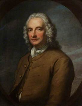
At the junction with Ralph Allen Drive, cross straight over and continue onto Church Street. Ralph Allen Drive is named after Ralph Allen. Allen arrived in Bath in 1710 and began work as a clerk in the local post office. His worked his way up the ladder quickly, becoming the Postmaster of Bath by the age of nineteen. Over the following decades he transformed the efficiency of Britain’s postal network, introducing reforms that greatly improved the system’s reliability and profitability. Allen also served as Mayor of Bath in 1742 and later represented the city as Member of Parliament from 1757 to 1764.
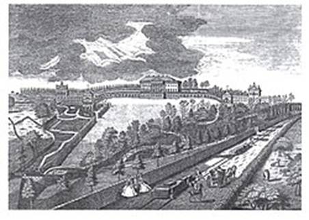
Allen acquired the stone quarries at Combe Down and Bathampton Down, supplying the distinctive honey-coloured Bath stone that built much of the Georgian city. The success of this enterprise brought him immense wealth and helped shape the architectural character for which Bath is now famous. To transport the heavy stone blocks from the hilltop quarries, Allen constructed a wooden wagonway running down from Combe Down to a wharf near the locks on the Kennet and Avon Canal. An engraving of Prior Park dating from 1752 shows this early railway passing the grand house Allen built for himself overlooking the valley. The wagonway evolved into the modern roadway we cross today preserving the memory of the industrial track that once carried the very stone used to construct the elegant Georgian city below.

Head down Church Street as the hill rises to Widcombe. The names of the surrounding parishes hint at the landscape’s far older origins. Widcombe and Lyncombe both derive from ancient Celtic words describing the valley environment here. Widcombe is generally understood to mean the ‘wide valley’, though it may also refer to a valley filled with withy trees, or willows. Lyncombe, meanwhile, refers to the valley of the Lyn Brook, a small stream whose watery course through the landscape earned the area the rather descriptive local nickname of ‘Watery Bottom’. Dominating the skyline above Widcombe stands the elegant spire of St Matthew’s Church. Built between 1846 and 1847, its slender tower rises to form one of the tallest church spires in Bath.
Take the footpath on the right, alongside the little river, and follow it up to Church Lane. This little lane was once a mule route running southwards towards the former deer park belonging to the Prior of Bath Abbey (also called Park Lane). Turn right to find the entrance gates of Prior Park. If closed, follow Church Lane to the end, if open, head straight into the gardens to enter the National Trust site.


Prior Park’s earliest parkland was established around 1100 by John of Tours, originally as a deer park, part of the medieval estate of Bath Abbey. In the 18th century, the park was transformed by the local entrepreneur Ralph Allen. By 1737, Allen had planted at least 55,200 trees along the valley sides and crest, while water was channelled into fishponds, creating a landscaped environment designed to impress visitors and frame the city views. During the 1750s and 1760s, the celebrated landscape gardener Capability Brown extended the gardens to the north, unifying the combe into a graceful, single sweep by removing the central cascade and opening panoramic vistas across Bath.


The park contains a remarkable collection of architectural and landscape features, including a Palladian Bridge, a Gothic Temple, a Grotto, an Icehouse, a Lodge, three ornamental pools, and a serpentine lake, all designed to blend with the natural curves of the valley. The Palladian bridge is one of only four in the world. Wilton House led the way in 1736 over the River Nadder followed by Stowe Palladian Bridge in Buckinghamshire, built in 1738, but wide enough for a carriage. Prior Park copied Wilton’s design in 1755. The fourth bridge was constructed in 1774 in Tsarskoye Selo, Russia. Wilton’s bridge has been made more famous by being the backdrop of Netflix’s Bridgerton’s promenade scenes, the location often mixed up with the Prior Park bridge, the only clear difference between the two being the dam set under Prior Park.


Following Ralph Allen’s death, the estate passed to his heirs. Allen’s successor, Earl De Montalt, shifted the focus from the stone business to developing Combe Down as a health resort, offering visitors an escape from the smoke and coal dust of the city. In 1993, the National Trust acquired the park and its pleasure grounds. A large-scale restoration began in 2006, carefully reviving the cascade, the serpentine lake, and the Gothic temple in the Wilderness area, the work featured in a special episode of Time Team.

Prior Park (National Trust) Opening Times click here


Overlooking the park and the city of Bath is the main house at Prior Park. Following a failed bid to supply Bath stone to London, Ralph Allen wanted a residence that would demonstrate the unique properties of Bath stone while proclaiming his success to the city below for all ‘To see all Bath, and for all Bath to see’. Initially, Allen commissioned the celebrated architect John Wood, the Elder, who had already designed notable Bath landmarks such as The Circus (1754–68). Construction began in the 1730s and 1740s, but disagreements between Allen and Wood led to Wood’s dismissal. His successor, Richard Jones, not only oversaw the completion of the house in 1743 but also designed the famous Palladian Bridge. Allen lived here as his primary residence until his death in 1764, enjoying panoramic views over the valley and the city that his stone had helped build.

In 1828, the house began its life in education when it was purchased by Augustine Baines, a Benedictine monk, for £22,000. Baines established two colleges within the wings of the mansion, dedicated to St Peter and St Paul, and Prior Park operated as a grammar school until 1904. During World War I, the estate was requisitioned by the army for officer cadet training, before reopening in 1924 as a boarding school for boys, a function it continues to serve today. The building has survived its share of challenges including two significant fires, and damage to the West Wing during the Bath Blitz of 1942. Despite these trials, the house remains a striking example of 18th-century Bath stone architecture.

After exploring Prior Park, take the footpath at the far end of Church Lane to climb up Claverton Down. Follow any of the trodden paths up the hill, through the open access land, to then meet a track at the top, which follows the Bath Skyline walk. Turn right as the views open up to survey the city of Bath, John Wood’s arced Circus visible in its heart. to the north.


Pass between the Monument Field, once home to a memorial tower erected to Allen by his nephew-in-law, but demolished in the 1950s, and the northern edge of The Priory, which was formerly the gardener’s cottage. Follow the boundary around to the left, over the now disappeared earthwork of Wansdyke (the defence against the Saxons) to meet a track and turn right to Claverton Down Road. Bear right crossing over onto Shaft Road as North Street continues back to Combe Down.


Combe Down sits atop the Roman road from Bath to Badbury Rings. Today, little remains of this road apart from a few Dorset sections and subtle earthworks south of Tucking Mill. Neighbouring the road was a Roman villa, discovered in the 1850s. Among the finds was an inscribed stone dating to AD 212–222, reading:
“PRO SALVTE IMP CES M AVR ANTONINI PII FELICIS INVICTI AVG NAEVIVS AVG LIB ADIVT PROC PRINCIPIA RVINA OPRESS A SOLO RESTITVIT”
This can be translated as:
“For the health of Imperator Caesar Marcus Aurelius Antoninus Pius Felix Invictus Augustus, Naevius the imperial freedman, helped to restore from its foundations the procurator’s headquarters which had broken down in ruins.”
It is also possible that the Romans quarried the local Bath stone in this area to construct the city’s famous baths and temples along the Avon valley.

Both Combe Down and Claverton Down sit above extensive 18th- and 19th-century Bath stone quarries, developed by Ralph Allen. Over the centuries, these quarries created a network of underground workings beneath the hills. Between 2005 and 2010, a central government-funded project stabilised and infilled many of these quarries to ensure the safety of the village above. Today, only one working quarry remains, the Upper Lawn Quarry off Shaft Road, which continues to produce high-quality Bath stone for buildings in Bath and across the UK.

Follow the stone wall lined, narrow road between the houses and past the football pitch to enter back into the parish of Monkton Combe. Bend with the road and take the footpath on the right, with a small bench on its junction to enjoy the view over Monkton Combe, the river, the lost railway and its last remaining chimney, to the Limpley Stoke Viaduct.


Follow the steep footpath, known as Drungs or Drongs, down the hill back into Monkton Combe. On joining the village road, continue straight ahead to find the car park and your vehicle at the village hall car park on the left.


